
Update: https://www.baltimorespokes.org/article.php?story=20100616101804156
An important planned trail that will connect the
Rock Creek Trail to
Lake Frank
is in jeopardy due to nearby homeowner opposition. This paved trail will be a
superb amenity that will greatly improve access to the lake, provide family recreational
opportunities and serve as a high quality bikeway. The trail will also be an important
piece of the future North Olney Trail that will link the Rock Creek Trail
to Olney five miles away, helping the environment by
supporting bike transportation instead of driving. But a group of neighbors who live
adjacent to Lake Frank is vociferously opposing the trail based on its proximity to
their homes, a problem we face all too often when new trails are built. To stop the trail
they are attempting to take away its state funding.
What You Can Do
Please send e-mails supporting the Lake Frank Trail to:
- Neil Pedersen, chief administrator of the State Highway Administration –
npedersen@sha.state.md.us - The Montgomery County Planning Board – mcp-chair@mncppc-mc.org
- The Montgomery County Council – county.council@montgomerycountymd.gov
- Your Maryland state delegates and senator if you can, especially if you live upcounty. Find your elected officials using MdSelect.net. Then go to the
Senate page or
House page for contact info.
Key Points
- Tell them you support the Lake Frank connector trail (or Lake Frank Trail)
- Tell them the trail should be paid for as planned, using ICC Environmental Stewardship funds
- Tell them why you enjoy trails or give any other personal thoughts
Sample Letter
(It’s helpful to add your own comments and personal perspective, such as why you use trails…)
To Mr. Neil Pedersen [or other recipient]:
I strongly support construction of the hard-surface Lake Frank Trail connecting the Rock Creek Trail to Lake Frank. I ask that it be built as soon as possible, and that it use state ICC stewardship funds as currently planned. I am a park user and will certainly benefit from this trail. The trail will be an important part of the countywide bikeway network and will support more trips by bike instead of by car. Please move the project forward. Thank you.
[signed, your name and city/community]
Additional Background
Opponents of the Lake Frank Trail first tried to reroute the trail to a much inferior location that would be farther from their homes. Having failed at that, they are now seeking to take away state funding already allocated for the trail. The state funds are provided by the ICC environmental stewardship program that’s paying for many projects including trails. Opponents are pushing to implement a parking lot removal project with the same funds so that no funds will be left for the trail. The parking lot project is worthwhile but is already slated to be done later and is not at risk. The trail is very much at risk due to neighborhood opposition.
Neighbors are saying they were not directly notified of the county’s intention to
build the trail using ICC funds. But there were numerous Gazette articles
talking about the
Upper Rock Creek Trail Corridor Plan as it was being developed, and that plan clearly states the county’s intention
to use ICC funds and consider a new alignment.
We all respect the lake. It is a more natural and uncrowded setting
than Lake Needwood. A single paved path passing through the
lake area is very consistent with that.
We also support construction of a continuous natural surface trail around the
entire lake to ensure a hiking experience that for the most part stays away from
the paved trail.
Neighbors opposing the trail are using the slogan “Take Back Our Lake”.
But we believe county parks belong to everyone and not just one community.
Index
- Gazette articles
and to the trail changes opposed by neighbors. - Plans and documents published by the county
- Printable flyer
Maps
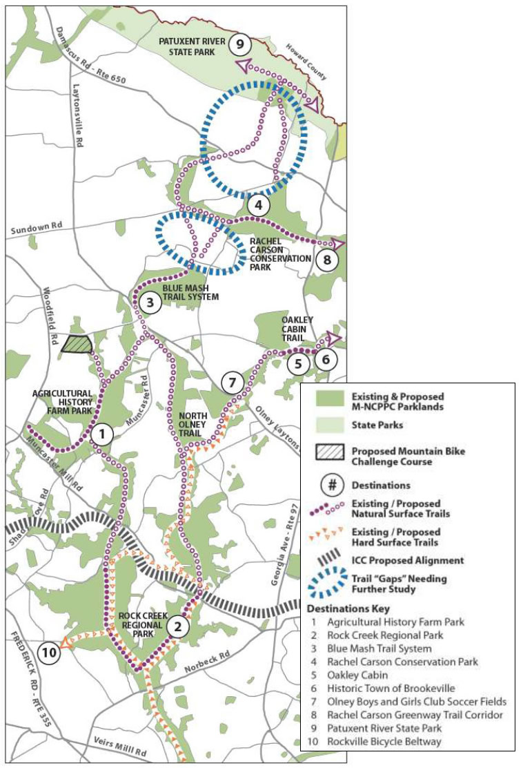
The above map shows the full North Olney Trail. It is the orange dotted
line starting roughly at the fork with the Rock Creek Trail (just south number “2”)
and ending at the number “7”.
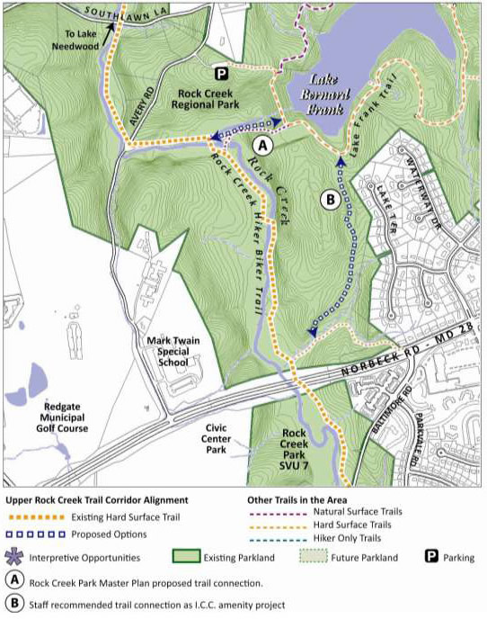
The above map shows the feasible route “B” embraced
by FHWA, the state and the county Parks Department. It also shows the non-feasable route “A” requested by neighbors
living on the streets shown. There is also an alternative “N” (not shown) that the neighbors have
been supporting lately, but it is probably not a workable route due to length and tree cutting.
Route “A” is not feasable because of considerably higher cost, rock cutting
and greater environmental impact (clearing, switchbacks).
Gazette Articles
These articles focus on
the Upper Rock Creek Trail Corridor Plan and most were written while the plan was being developed and public
input was being taken. The plan clearly states the county’s intention to use ICC funds to build the trail.
The articles themselves actually note the change to the Lake Frank Trail alignment that neighbors say they were
unaware of.
Question:
How could community associations that back up to Rock Creek Park
be so inattentive that they were
unaware of the development of the Upper Rock Creek Trail Corridor Plan despite all these articles in the county’s newspaper?
The VP of the umbrella Montgomery County Civic Federation even attended one of the public meetings.
In most counties, a Parks Department that publicizes a plan through press releases and sees
its verbiage
quoted verbatim
in several newspaper articles would consider its public notification responsibilites to have been fulfilled.
Mixed views aired on Upper Rock Creek hiker-biker trail (10/31/07)
—
Excerpt:
Last week, Department of Parks staff hosted a community meeting in Derwood to discuss and gather
suggestions on the Upper Rock Creek Trail Corridor Plan. The meeting was the second of its kind; the first was held in May of last year. … Arnold Gordon, president of the Norbeck Meadows Civic Association in Olney and first vice president of the Montgomery County Civic Federation, expressed concern over the challenge course causing ‘‘environmental degradation.” …
Coleman said park staff tries to keep trails in designated park areas. She said if that cannot be accomplished because of environmentally sensitive areas or for other reasons, staff would create landscape buffers to separate the trails from residential properties. …
Others, though, seemed supportive of extending trails into neighborhoods so that they would not have to drive to a park
in order to access the trails…
Upcounty trail gaps to be filled —
Connections will give hikers, bikers and riders a 30-mile path (6/26/08) —
Excerpt: The plan’s highlights include almost doubling the length of trails now available in the corridor,
endorsing the extension of a hard-surface trail from Rock Creek Regional Park to Olney, proposing a new
alternative to link the Rock Creek hiker-biker trail to the Lake Frank trail network in Derwood,
creating a mountain bike challenge course at Carson Farm Special Park in Gaithersburg and adding
signs about historic mill sites along the way.
Public hearing set for Trail Corridor Plan —
Meeting to be held on Sept. 1 (9/10/08) —
Excerpt: …proposing a new alternative to link the Rock Creek hiker-biker trail to the Lake Frank trail network in Derwood…
Residents urge board to fill out trail system (9/16/08) —
Excerpt (repeating ourselves): …providing a new alternative to link the Rock Creek hiker-biker trail to the Lake Frank trail network in Derwood…
Planning Board approves trail corridor plan (9/30/08) —
Excerpt (repeating ourselves again): …providing a new alternative to link the Rock Creek hiker-biker trail to the Lake Frank trail network in Derwood…
Documents
- 2008 Upper Rock Creek Trail Corridor Plan –
https://www.montgomeryparks.org/PPSD/ParkTrails/trail_planning/upper_rockcreek/documents/urctcp_sept25_2008_web.pdf
- The full North Olney Trail is shown on page 2 (and also on this web page).
- Lake Frank Trail alternatives are shown on page 22 (and also on this web page).
-
Excerpt:
“Implementation Priorities: …
Implement the trail connection of Lake Frank and Lake Needwood as an ICC community
enhancement project…” -
Note the trail triangle formed by the North Olney Trail, ICC Trail and Rock Creek Trail (all paved), which will facilitate direct
travel from each trail to each of the other two (as well as provide an attractive trail loop). - Trail Names — We consider route “A” to be part of the Lake Frank Trail which runs along the east side of the lake.
The Lake Frank Trail will be part of the North Olney Trail when it’s built.
It’s largely semantics. - This is not a master plan.
- 2008 Countywide Park Trails Plan –
https://www.montgomeryparks.org/PPSD/ParkPlanning/documents/cwptp_sept08_web.pdf
- This is not a master plan.
Other Contacts (FYI)
Montgomery County Planning Board
www.montgomeryplanningboard.org
Dr. Royce Hanson, Chairman (
MCP-Chair@mncppc-mc.org)
301-495-4605 (phone)
The Planning Board is an appointed board of five members that represents the Maryland National Capital Park and
Planning Commission (M-NCPPC) in Montgomery County. It heads up the Montgomery County
Planning Department and the
Montgomery County Parks Department.
Donna Edwards, U.S. House of Representatives
See contact info and district map.
Montgomery County Executive
Isiah Leggett, County Executive
ocemail@montgomerycountymd.gov
Webpage is here.
240-777-2500 (phone)
Maryland Governor
Martin O’Malley, governor
Email: governor@gov.state.md.us
410-974-3901 (phone)
1-800-811-8336 (toll free)
Special mention…
We support the WABA (Washington Area Bicyclist Association)
This page sponsored by MoBike (Montgomery Bicycle Advocates) at www.mobike.org
Send us an email at…
https://www.internetigloo.com/mobike/lakefrank/oldId.20100522162614788
I take issue with your insensitivity to what is really a complex situation. I am a 30yr biker, and I live on a cul-de sac near Lake Frank. I bike to the store often, and do a long commute one day a week.
This lake was named for Bernard Frank, a Wilderness Society founder, C&O canal savior, and has been kept natural. People come to it from miles around to hike, run, fish, and bird and enjoy the largely unspoiled circular path around the lake. The unspoiled trail complements the Meadowside nature trail on the other side of the stream. Lake Needwood, on the other hand has roads, paving, boat/food concessions, playgrounds, and has been trashed up.
While it is great to have a paved bike path, it is insensitive to a lot of other people who enjoy Lake Frank largely unspoiled. Some of my biker friends (who also run) think this idea is just plain dumb.
We got duped by the ICC folks when they promised us a bikeway, and then bait and switched us when we bought into their phony scheme. We do not mitigate a highway by paving a park.
There is a great power line right of way on the side on Lake Needwood that runs right up to Rt108. Now that is something we could use for a great bikeway. See the link below.
xxhttps://maps.google.com/maps?ll=39.122706,-77.12334&z=16&t=h&hl=en
Nate