
[B’ Spokes: Coming to a random mail box near you (if approved.)]
******************************************************************************
By Charles Pekow, Examinar
So how many people got to their recreational destinations by what form of transit? The Federal Highway Administration (FHWA) at the United States Department of Transportation (DOT) wants to know and has proposed asking about it in its 2015 National Household Travel Survey (NHTS). FHWA is taking public comments on the proposed survey, which needs permission from the Office of Management & Budget (OMB). FHWA announced the plan in the Federal Register of Tuesday, April 28, 2015.
FHWA wants to know who is using what form of transportation to get where they are going. FHWA plans to use the findings to help gauge factors such as safety, energy use, air pollution, congestion and safety; and to help determine research needs. It wants to know how many people are walking, biking, driving their own car or taking public transit to recreational and other destinations. FHWA also plans to share the data with state agencies so they can do the same type of evaluations.
…
https://www.examiner.com/article/federal-survey-planned-on-transit-to-recreation
Ryan Dorsey for Baltimore City Council 3rd District
“He is a member of the Transit Choices coalition, seeking improvements in safety and effectiveness in Baltimore City transportation”
[B’ Spokes: He supports cycling.]
https://www.electryandorsey.com/
BikePed Beacon :: April 2015
In This Issue:
* Bike to Work Day to celebrate alternative commuting options, safety on Friday, May 15
* Bike to School Day and Walk to School Day campaigns aim to inspire children into action
* Baltimore City adopts 2015 Bicycle Master Plan
* Howard County launches bicycle, pedestrian master plans
* Funding available for bicycle, pedestrian and trail projects
* News & Resources
https://campaign.r20.constantcontact.com/render?ca=f1d861d1-8f03-4648-b7c9-de0bf3cc354e&c=d01a4880-3276-11e3-8d5a-d4ae526edc76&ch=d0bf8930-3276-11e3-8e1f-d4ae526edc76
Planning Commission Officially Adopts Baltimore’s Updated Bike Master Plan
Via Baltimore City Department of Planning April Newsletter
Planning Commission Officially Adopts Baltimore’s Updated Bike Master Plan – To Create a More Bike Friendly Baltimore
On March 26, 2015, the City of Baltimore’s Bike Master Plan was officially adopted by the Planning Commission, which will lead to the expansion of the city’s biking network, and create a more bicycle-friendly environment in Baltimore.
Since the adoption of the City’s first Bike Master Plan in 2006, Baltimore has made significant progress in becoming more bicycle-friendly. Over 125 miles of bike facilities have been installed to provide a network of bike lanes and trails.
The City has also installed over 600 bike racks in neighborhoods throughout Baltimore, for safe and convenient bicycle parking.
The Department of Transportation’s (DOT) 2015 update to the Baltimore City Bike Master Plan outlines a 15-year plan for bicycle infrastructure and policies developed based on national best practices and public input. The updated Plan proposes a comprehensive bicycle network where bicycle facilities will be designed based on the specific street context.
Vision:
To increase bicycling and its associated health, economic, and environmental benefits, the City will focus on creating safe and user-friendly bicycle infrastructure as part of its commitment to Complete Streets and multi-modal transportation options.
…
Visit the DOT Bike Master Plan website for the full plan and additional information:
https://archive.baltimorecity.gov/Government/AgenciesDepartments/Transportation/BicycleMasterPlan.aspx
Tour dem Parks, Hon! is Sunday, June 14th, 2015
Register before May 1st and adults ride for $40 each (save $10) and kids 15 & under ride for $20.
New this year! The Tour starts and ends in Druid Hill Park! Riders choose from 3 routes – 14 miles on the newest section of the Jones Falls Trail, 25 miles, or 35 miles. Tour dem Parks, Hon! is fully supported with rest stops and ends with a jazz barbecue in Druid Hill Park. See photos from past rides here.
…
https://campaign.r20.constantcontact.com/render?ca=05442ff9-14d5-461a-a790-52772b4cc106&c=db6fab80-5102-11e3-a981-d4ae5292b9a6&ch=dc7a3db0-5102-11e3-a9b5-d4ae5292b9a6
County Planning Board Supports New Maryland Law on Designating Bicycle and Pedestrian Priority Areas
by Bridget Schwiesow, Montgomery Planning Board
SILVER SPRING, MD –The Montgomery County Planning Department, part of The Maryland-National Capital Park and Planning Commission, helped to initiate a new Maryland law requiring the State Highway Administration to act within one year on local designations of Bicycle-Pedestrian Priority Areas. Work on the newly enacted law began with a collaborative effort among County Transportation Planner Larry Cole, Maryland House Delegate Alfred Carr, Jr. and Kelly Blynn of the DC regional Coalition for Smarter Growth.
Maryland Senator James Rosapepe introduced the bill on February 6, 2015 and, on February 12, 2105, the Planning Board voted to support it. The final Senate Bill 371 was signed by Governor Larry Hogan on April 14, 2015: https://mgaleg.maryland.gov/2015RS/bills/sb/sb0371T.pdf
The designation of Bicycle-Pedestrian Priority Areas is intended to ensure that the needs of bicyclists and pedestrians are taken into account during all phases of transportation planning, design, construction or expansion. The aim is to provide for greater safety and access through bike lanes, paths, sidewalks, crosswalks and other physical road improvements and traffic control devices. Bicycle-Pedestrian Priority Areas have become an integral part of Montgomery County’s recent Master Plans, developed by the Planning Department to promote multi-modal transportation in the more densely developed areas of the County.
…
https://montgomeryplanningboard.org/blog-news/2015/04/16/county-planning-board-supports-new-maryland-law-on-designating-bicycle-and-pedestrian-priority-areas/
And another: https://www.bethesdanow.com/2015/04/16/quicker-bicycling-improvements-possible-thanks-to-new-state-bill/
************”************************************************************************************************************************************
[B’ Spokes: While this is good news still, I wounder how many other counties are going to take advantage of this funding opportunity. Ya I’m looking at you Baltimore County and Prince George Counties. Far too many cycling related deaths and injuries and such a low mode share to even remotely justify current practice of ignoring accommodating bicycles.]
Tucson will pay $225,000 to settle a lawsuit involving an injurious pothole.
By Becky Pallack, Arizona Daily Star
“Ken Baarson was riding his bicycle on East Pima Street near North Sonoita Avenue in July 2012 when he thought he saw a puddle of muddy water. He tried to ride through it but the puddle turned out to be a deep pothole filled with water, caused by a leaking pipe under the pavement.”
https://m.tucson.com/news/local/city-settles-pothole-injury-lawsuit-for/article_9a75d676-c180-57e3-8ce1-b03366964186.html
************************************************************************************************************************
[B’ Spokes: The city of Baltimore should take notice of this liability.]
Bicyclist injured in hit-and-run on Philadelphia Road
Via WBALTV
…
Anyone with information about the incident is asked to call police at 410-307-2020.
https://www.wbaltv.com/news/bicyclist-injured-in-hitandrun-on-philadelphia-road/32304042
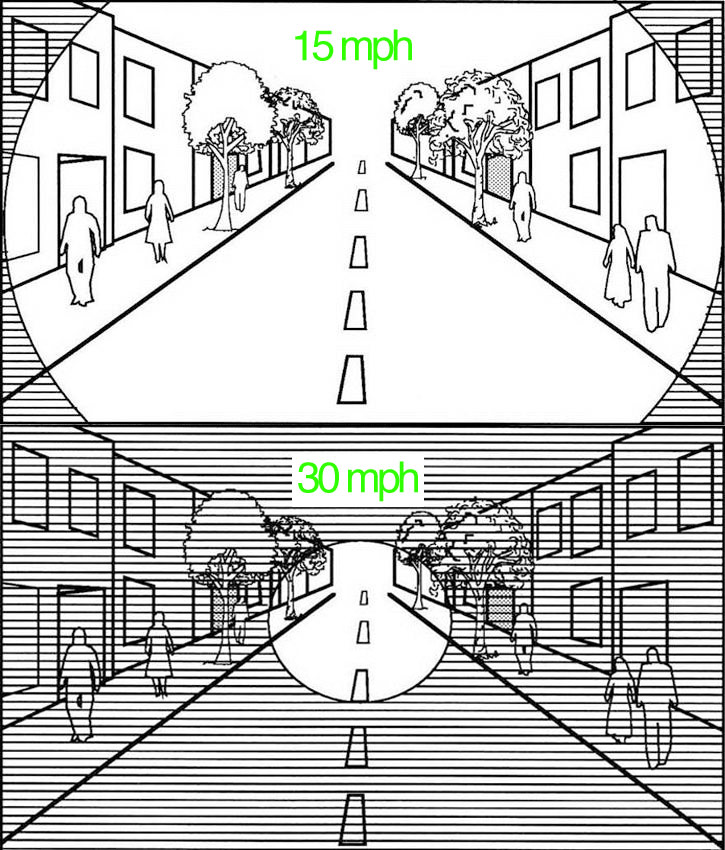
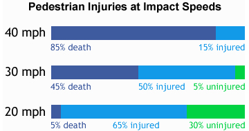
The Critical Ten
[B’ Spokes: I’m posting this because I think the speed limit on the most northern part of Roland Ave (where Tom was killed) is too high. Why does anyone “need” to travel 35 mph for ~ 1/2 mile when the rest of the street is 25 mph?]
By Bill Lindeke, Streets MN
The problem is that for a good urban street, this muddy “middle ground” between ‘walkable’ and ‘driver’s paradise’ can sometimes be the worst of both worlds.
…
…
The Critical Difference Between 30 and 20
I’m talking about traffic speed. If you look at the average speed of traffic on a urban commercial streets, there are a lot of things that begin to change when you slow down cars from the 30 to 35 mile per hour range into the 20 to 25 mile per hour range. Most importantly, perception, reaction time, and crash outcomes are far better at 20 than at 30 mph, while traffic flow doesn’t seem to change very much.
…
…
TRANSPORTATION ENGINEERS QUESTION USE OF COMMON PRACTICES & METRICS
-> This month, for at least the second time in a year, the Institute of Transportation Engineers has challenged its members to rethink common practices and metrics that are often thought of as objective and unbiased, but that convey values that arent necessarily in line with the greater public interest. In particular, these values emphasize the movement of vehicles above all other interests.
In an op-ed for this months ITE Journal (https://bit.ly/1yUOu8l), Jason DeGray, a licensed engineer and a member of the groups advocacy committee… argues that conventional approaches to engineering, developed over years of outward suburban growth, are particularly biased toward motorized road users–most noticeably in urban areas.
A feature article in the ITE Journals August 2014 issue, titled Decisions, Values, and Data: Understanding Bias in Transportation Performance Measures (https://bit.ly/1CeAI1D), gives an example of one such metric–level of service–explains precisely how it reflects values and biases inherent to transportation design… [https://bit.ly/1c5G4WK]