[B’ Spokes: This would have been perfect if somehow connected to the aquarium.]
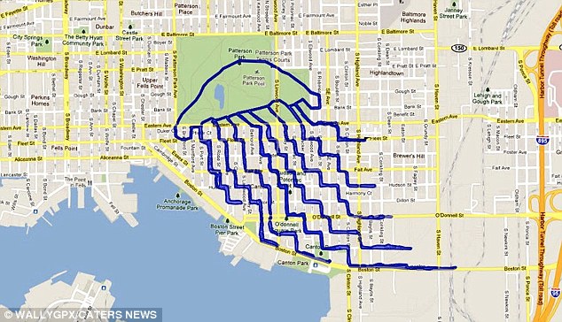
For more pictures: https://www.dailymail.co.uk/news/article-2091553/Going-grid-The-artist-creates-pictures-street-maps–help-GPS-bike.html

Biking in Baltimore
[B’ Spokes: This would have been perfect if somehow connected to the aquarium.]
For more pictures: https://www.dailymail.co.uk/news/article-2091553/Going-grid-The-artist-creates-pictures-street-maps–help-GPS-bike.html
[B’ Spokes: Typical, great bike plan but no funding. One day people are going to realize that a plan without funding is the same as no plan at all… but that’s how we accommodate cyclists in Maryland. Also note the required match comment, Federal aid is OUR money and not the States and it’s not right that the State [MDOT] is putting up barriers to keep that money from the localities. But that might be mute with the next authorization of the transportation bill and all that funding that has built up over the years will disappear.]
***************************************************************************************
By Matthew Bieniek, Cumberland Times-News
CUMBERLAND — Passionate advocates for walking, hiking and biking traded ideas, concerns and discussed the future in a wide-ranging discussion during a Thursday afternoon open house dedicated to the Allegany County Bicycle and Pedestrian Master Plan.
“I see Allegany County as a destination for families, with something everyone can do,” said Jim Christie, a planner with Thrasher engineering, who is heading up plan development with Siera Wigfield, a county planner. “We want everyone to get excited about thew project,” Christie said. And everyone in the room seemed to be excited as comments and questions went back and forth between members of the audience, Christie and Wigfield.
Topics ranged from the crossing at Depot and Main streets in Frostburg to the larger questions of funding and organization.
“In Frostburg, one issue is getting people from Depot Street across to Main Street. You can’t do it,” said Maureen Brewer. The intersection is very busy and several fast food restaurants are in the area. Brewer is a member of Frostburg First and Mountain Maryland Trails.
“I love the trail recreationally, I just wish it was more utilitarian,” said Dawn Hartlaub.
Doug “Hutch” Hutchins discussed the need for some driver education on bicyclists and keeping them safe. He also asked about funding and government support. Hutchins owns Cumberland Trail Connections and is a board member of Mountain Maryland Trails. Hutchins suggested a partnership between police, county officials and the newspaper to promote bicycle safety, especially around busy crossings.
Sometimes, government has impeded trail development and access.
“There are always excuses … these things can be overcome,” Hutchins said.
“I don’t think most people have a clue (about the rules for drivers encountering pedestrians and bicyclists),” said Nancy Forlifer of the Western Maryland Health System.
Funding is not part of the plan and will ultimately depend on government and interested organizations. Having a plan, though, will provide a good start toward obtaining the funds, said Christie.
Mayor Butch Armentrout of Carpendale, W.Va., said grant money is still out there but that most of it required a match. For small municipalities, that can be a challenge, he said.
…
Continue reading “Plan in motion for bicyclists, pedestrians – Funding not part of county trail network proposal”
By Penny Riordan, Patch
Part of the long-term bicycling and pedestrian improvements for western Baltimore County include a pilot project for designated bike route between UMBC and the MARC Station in Halethorpe.
…
https://catonsville.patch.com/articles/county-will-establish-bike-route-between-umbc-and-marc-station
**************************************************************************************************************************************
[B’ Spokes: Destinations a bit further south across US 1 and I-895 would have been really nice, that’s a bear of an area till you figure out the the bike friendly routes. This is a nice start but we would not build a road that began and ended at UMBC and MARC so why do that with a bike route? ]
2nd Session: Advanced Bicycle Maintenance Class March 6-7
Due to popular demand (the class filled up in 48 hours), I will be offering a second Advanced Bicycle Maintenance Class.
Date: Tuesday, March 6 and Wednesday, March 7.
Time: 6:30pm-9:30pm.
Session 1(Tuesday): fundamentals of a bike, what tools are good to have, basic maintenance tips, full drive train cleaning and repair assessment.
Session 2 (Wednesday): brake adjustment, derailleur adjustment, bottom bracket, hub and headset adjustment and the replacement/repair of any simple repair needed on your bike.
Students are encouraged to bring and work on their own bike. The cost is $125 which includes a copy of "The Haynes Bicycle Book" – my favorite repair manual. 🙂
Class is limited to 8 students. Come join us. Everyone learns a lot and it’s great fun. Please call the shop at 301-441-2928 to reserve your spot.
Jill DiMauro
Proteus Bicycles in College Park.
email: jill@proteusbicycles.com
web: https://www.proteusbicycles.com
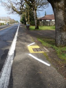 Photo credit: Jim Parsons
While I appreciate the efforts to have bike “safe” grates so no one seriously injures themselves but still drains not level with the road surface or poor pavement quality around the drain (almost always happens in a short time span) really cannot be called bike friendly, so hazard markings like shown and described in AASHTO should be applied. But sadly I know of no place in Maryland were such a treatment can be found, what’s up with that anyway?
Continue reading “Please Sir, can we have this here?”
[B’ Spokes: When I read this I could not help but think of conversations from the state around wanting to put rumble strips everywhere. We are designing streets that encourage overrun by motor vehicles and then try to do something else that has little to no effect on the subject or worse discourages biking and walking.
I will also note that while accommodating fast travel by motor vehicle has it’s place, but that place is NOT on every single street.]
by Eric Dumbaugh
…
In this study, I
examine the subject of livable streetscape
treatments and find compelling evidence
that suggests they may actually enhance
the safety of urban roadways. Concerns
about their safety effects do not appear
to be founded on empirical observations
of crash performance, but instead on a
design philosophy that discounts the
important relationship between driver
behavior and safety. This study traces the
origin and evolution of this philosophy,
and proposes an alternative that may better account for the dynamic relationships
between road design, driver behavior, and
transportation safety.
…
Beyond simply acting as thoroughfares for motor vehicles, urban streets
often double as public spaces. Urban streets are places where people walk,
shop, meet, and generally engage in the diverse array of social and recreational activities that, for many, are what makes urban living enjoyable. And
beyond even these quality-of-life benefits, pedestrian-friendly urban streets have
been increasingly linked to a host of highly desirable social outcomes, including
economic growth and innovation, improvements in air quality, and increased physical fitness and health,
to name only a few. For these reasons, many groups and individuals encourage
the design of “livable” streets, or streets that seek to better integrate the needs of
pedestrians and local developmental objectives into a roadway’s design.
…
Interestingly, clear zones are not the only design feature for which such safety anomalies appear. Hauer
reexamined the literature on lane widths and found that
there was little evidence to support the assertion that
widening lanes beyond 11 feet enhances safety. Instead, the
literature has almost uniformly reported that the safety
benefit of widening lanes stops once lanes reach a width of
roughly 11 feet, with crash frequencies increasing as lanes
approach and exceed the more common 12-foot standard.
…
Thus, a key question emerges: why does contemporary
design guidance recommend practices that the best available evidence suggests may have an ambiguous or even neggative impact on safety, and paradoxically, to do so under
the auspices that they constitute a safety enhancement?
…
One of the key problems identified by the AASHO
committee was the large number of fatalities associated
with single-vehicle, run-off-roadway crashes. To address
this issue, they heard testimony from Stonex, a General
Motors employee responsible for designing the “Proving
Ground,” an experimental “crashproof” highway that had
100-foot clearances on either side of the travelway. Based on the test performance of
the Proving Ground, Stonex was of the opinion that “What
we must do is to operate the 90% or more of our surface
streets just as we do our freeways . . . [converting] the surface
highway and street network to freeway and Proving Ground
road and roadside conditions”
…
As shown in Table 3, the livable section is safer in all
respects. By any meaningful safety benchmark—total midblock crashes, injuries, or fatalities—there can be little
doubt that the livable section is the safer roadway.
…
Pedestrian and bicyclist injuries were likewise higher
on the comparison section (see Table 4), which may be
partly attributable to the fact that the livable section provides parked cars and fixed objects to buffer pedestrians
from oncoming traffic. But do the benefits in pedestrian
safety outweigh the hazards these features may pose to
errant motorists?
…
While these results seem to contradict conventional
design practice, they confirm a trend that many researchers
and practicing engineers have observed for some time, but
which has received little substantive elaboration: specifically,
that clear zones and other forgiving design practices often
have an ambiguous relationship to safety in urban environments, and may be associated with declines in safety performance. The best possible explanation for the enhanced
safety performance of the livable sections considered in this
study is that drivers are “reading” the potential hazards of
the road environment and adjusting their behavior in
response.
…
The reason why this subject has not received greater
attention in design literature and guidance appears to be
that it contradicts the prevailing paradigm of what constitutes safe roadway design. Nevertheless, a behavior-based
understanding of safety performance is supported by
research and literature in the field of psychology, which has
focused on the subject of traffic safety as a means for understanding how individuals adapt their behavior to perceived
risks and hazards.
…
The presence of features such
as wider lanes and clear zones would appear to reduce the
driver’s perception of risk, giving them an increased but
false sense of security, and thereby encouraging them to
engage in behaviors that increase their likelihood of being
involved in a crash event. If so, this explains why the livable
streetscape treatments examined in this study resulted in
not only fewer fixed-object crashes, but fewer multiple
vehicle and pedestrian crashes as well. … From the perspective of risk homeostasis theory,
the use of high design values is not “forgiving,” but is
instead “permissive.”
…
The passive approach promotes designs intended to
support high-speed operating behavior, and then attempts
to mitigate a roadway’s hazards through the use of signs
and pavement markings. The problem that emerges, however, is that signs and roadways are often communicating
contradictory information. The result is that the majority
of drivers in urban areas disregard posted speed limits, and
seem to learn to disregard road signs altogether, even when
they display information that is essential to their safety. … This latter finding
suggests that even conscientious drivers may be unable to
comply with posted speed limits when roadways are designed
for higher-speed operation.
…
I have argued that many of the safety concerns that
emerge on urban streets result from design practices that
fail to link a roadway’s design to its environmental context,
thereby providing motorists in urban environments with a
false sense of security and increasing their potential exposure to crashes and injuries. I have further provided a theoretical framework that better accounts for the safety anomalies one observes when examining the literature and data
on the crash performance of urban roadways. Yet theory is
only the first step. There is a clear and demonstrated need
to better develop our professional understanding of the
relationship between driver behavior and transportation
safety, as well as to enhance our overall approach to the
design of urban roadways. This study thus concludes with
the hope that by better understanding the relationship
between design, driver behavior, and safety, we can design
roadways that are not only safe, but also livable.
Continue reading “Safe Streets, Livable Streets”

[B’ Spokes: I’ll note that I am not in favor of this, two lane roundabouts are not that bike/ped friendly and all this does is make traffic on Key Highway and Light Street near continuous creating a car sewer barrier between Federal Hill and the Inner Harbor. Two major bicycle and pedestrian areas. If we can’t dial up road designs to be pedestrian friendly here, where can we? Baltimore needs to get that it is the pedestrian traffic that makes this area great and it is not the 8,000 vehicles wishing to bypass this area. I know it sounds like they are accommodating bike/peds in the linked article but NOT at the desired crossing points and not by best practices, this concerns me a great deal.
Also note all the bike/ped friendliness of roundabouts studies that I know about reference ONE lane roundabouts and it is my assertion that those features do NOT carry to a two lane roundabout, though this has not been studied yet as far as I am aware.]
By Penny Riordan, Patch
…
Catonsville resident Charlie Murphy, who rode his bike to the meeting, said the bike plan brings Baltimore County closer to what has happened in Baltimore city, where there are dozens of roads with dedicated bike lanes.
What the plan does is create a more comprehensive approach to bike and pedestrian routes, which allows people to do short trips and find ways to get from one area to another, he said.
"One trail is not the answer, you have to build the network," he said.
Continue reading “Catonsville, Arbutus Residents Praise Bike Plan”
Via Facebook:
To all students at MICA and UB: Your administration has approved improvements to their area in what’s known as the Midtown Streetscape Project, but they and the city have rejected the addition of bicycle infrastructure, such as bike lanes. You, the students, can make your voices known. Call, write, email, and approach the administration about this. The city can make cycling more convenient, but you have to speak up.
Thank you for supporting safe biking in Howard County. In case you haven’t recently visited the BAHC website, https://www.BikeHoCo.org, we wanted to make you aware of our new fundraisering effort with Road ID – the foremost emergency ID products for cyclists, triathletes, and runners. Through a partnership with Road ID, BAHC is offering their innovative products to the community with a portion of your purchase going as a donation to support the BAHC goals of:
* Working with the County to develop a Howard County Bicycling Master Plan
* Supporting physical road improvements (paving, better shoulders turn lanes, ‘Share the Road’ sign, etc.)
* Fostering driver and bicyclist education and communication initiatives
* Functioning as local bicyclists link with HC Police, Public Works and other local Government
Many of you may have changed insurance this year or contact information or never had a Road ID before. Whether you order through BAHC or not carrying some form emergency identification is essential – ask any of us who have been in accidents. While their products are designed to keep athletes safe Road IDs also make great gifts for those with medical condition, kids and older adults.
In order for BAHC to get a donation from your purchase you must use the Road ID link for shopping found on the lower left of the BAHC homepage https://www.BikeHoCo.org or you can paste the address below into your browser (Mac users need to use Safari): https://www.roadid.com/Common/default.aspx?referrer=8474.
Please pass this information to your Club listserves and other cyclists you know.
Thank you for considering this as another way of supporting BAHC and Safer Cycling!
Jack
Jack Guarneri
President, Bicycling Advocates of Howard County
https://www.BikeHoCo.org